| « | TrackMyJourney |
» |
I've written before about my little "black box" Bluetooth GPS and the TrackMyJourney software but today I've explored it some more.
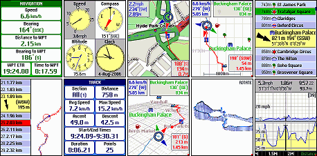
TrackMyJourney is an incredibly powerful bit of software which runs on compatible mobile phones, essentially ones that run a Java VM like my Sony Ericsson K800i, listens to the GPS black box over bluetooth and uses that data to give you all sorts of information derived from the GPS data, as these screen shots show:

You need to squint a bit but it's really very impressive stuff. Take a look at the documentation to see lots more screen shots which will give you more of a feel for how it looks.
What originally interesting me in the software was for what it said on the tin: the "track my journey" aspect, where it uses a data connection to update your location in real time to a mapping web site.
My interest has changed now however.
Beth's off to Scotland for a week or so and she's taking my main GPS, the Garmin Foretrex 101, with her. So I was thinking about what else I could use if I went walking and so went back to look at TrackMyJourney again.
 And the news was good. For a start it could do routes, just like the Foretrex. So I could create a route using our mapping web site. That gave me a GPX file which I then had to convert to OZI format, which was no problem using gpsbabel. All I had to do then was bung it onto the phone via bluetooth and import it into TrackMyJourney. Then I could follow the route. It's easy: an arrow points to the next point on the route and gives you distance to it. Meanwhile a graphical display shows both your route and track. Very nice.
We played with it today while walking to The Wrestlers and it worked pretty well. The main problems were that the screen is quite hard to read in bright sunlight and they're using black text on a red background for part of it. But still good though.
It's got lots of other goodies too, like ETA and kCal used (with different figures for running, cycling and walking). It's really very cute software.
When we got back I started reading about what it can do with maps. It turns out you can put any map image on there, give it top left and bottom right corner coordinates and it will then show you where you are on the map as you walk along. So I've now got the local area 1:50,000 OS map on my phone and it does indeed show me where I am.
Of course I know where I am around here but this is really just playing with the technology. Once I'm happy it works I'll do some maps for places like The King's Forest where we often go.
Whether, given my current lack of mobility, I'll actually get to go far while Beth's away is another question. But with my disabled person's railcard and my free bus pass there are some interesting possibilities ...
| Tags: maps, toys, walks | Written 20/09/08 |
| « | » |

